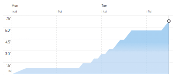
Snow Event: Monday 11/27/2023

Event Forecast Timeline
Rain is expected to turn to snow early Monday morning, however, with temperatures hovering right around freezing, we don't anticipate it sticking right away. Most accumulation is expected to occur late Monday night through Tuesday morning.
Forecast Impact
Current forecasts are calling for 4-8 inches of snow to fall between Monday morning and Tuesday evening
Landscaping by Mark & Sons’ Response Plan
Dispatch Time: 6:00 am
We anticipate dispatching plows in the early hours of Tuesday morning, but we will continue to monitor the weather and post updates.
Live updates will appear below.
5:30 am
The two inch trigger has been met and all drivers are on their way in.
7:45 am
Due to a lock freezing, one of our drivers is delayed. Help is on the way, and although they slid off the road momentarily, they are safe, back en route, and should be there shortly. Despite the challenging conditions, our other drivers are making steady progress and will assist when they are able to. As much as we prepare for snow events, unexpected challenges still happen, please be patient with us. Thank you for understanding and stay safe out there!
9:30 am
The issue has been resolved and the last remaining driver has started their route. Drivers are reporting icy conditions and several unplowed roads, please stay safe!
1:45 pm
All routes are complete. Thank you for your patience!